
Extreme Ice. Art meets science in photographer James Balog's Extreme Ice Survey. The project, begun in December 2006, will attempt to capture global warming in the act using 26 solar-powered cameras taking time-lapse photographs of glaciers in Greenland, Iceland, Alaska, the Alps, and the Rocky Mountains. Balog hopes the ambitious effort, which will produce more than 300,000 images over the course of two years, "radically alters public perception of the global warming issue."

Iceland Icebergs. Decaying ice and icebergs crowd Jökulsárlón, a glacial lagoon in southeast Iceland. The 2.5-by-3-mile (4-by-5-kilometer) lagoon began to form in the 1930s as glaciers from the Vatnajokull icecap started to retreat.

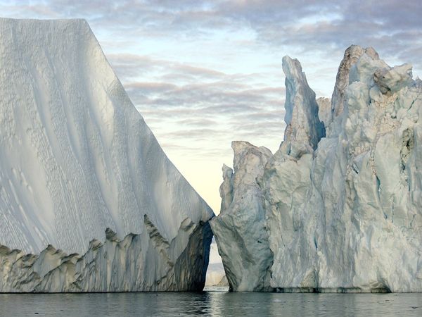
Colliding Icebergs. These massive icebergs were calved from Greenland's Jakobshavn Glacier, a massive frozen river that sends 11 cubic miles (45 cubic kilometers) of ice into the ocean each year, more than any other glacier in the Northern Hemisphere. "Jakobshavn is the biggest of the big," says photographer James Balog, founder of the Extreme Ice Survey. Balog and his research partners encountered faulty electronics, heavy equipment, and foul weather when they installed 26 solar-powered, time-lapse cameras at 16 glaciers in five countries. The few that Balog has revisited are operating well. "So far, so good," he says.
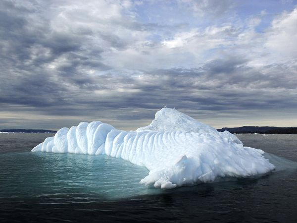
Seagulls and Iceberg. This doughy-looking iceberg in western Greenland's Disko Bay was once part of the enormous Jakobshavn ice stream, a river of ice four miles (six kilometers) wide and several thousand feet thick.
The Extreme Ice Survey is focusing heavily on Jakobshavn, which in the past decade has retreated at about 120 feet (37 meters) per day, twice its normal rate.
The Extreme Ice Survey is focusing heavily on Jakobshavn, which in the past decade has retreated at about 120 feet (37 meters) per day, twice its normal rate.
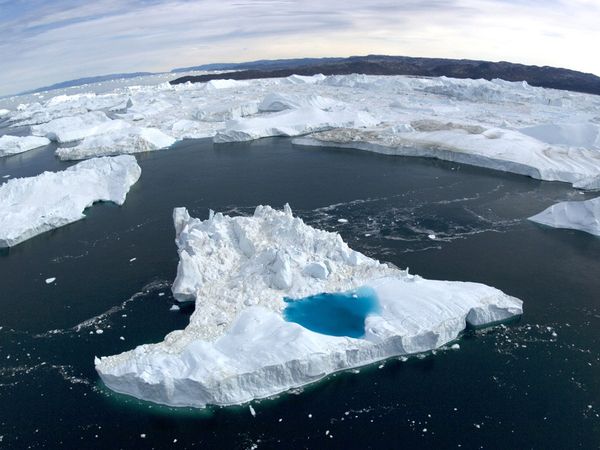
Meltwater Pool. Icebergs, including one with a sapphire pool of meltwater, clutter Greenland's Jakobshavn Fjord near the village of Ilulissat. The glacier that produced this flotilla has receded some four miles (six kilometers) since the year 2000.
Glaciers such as Jakobshavn are calving icebergs much faster than scientific models had predicted they would. The ongoing Extreme Ice Survey hopes to shed some light on why these so-called tidewater glaciers, which end in water instead of land, are being lost at such a rapid rate.
Glaciers such as Jakobshavn are calving icebergs much faster than scientific models had predicted they would. The ongoing Extreme Ice Survey hopes to shed some light on why these so-called tidewater glaciers, which end in water instead of land, are being lost at such a rapid rate.
Harrison Glacier. Bare rock and meltwater pools mark the edge of the shrinking Harrison Glacier in Montana's Glacier National Park. Of the 150 glaciers found in the park a century ago, only 27 remain. And scientists predict that by 2030, those will all be gone.
In 2008, photographer James Balog, founder of the Extreme Ice Survey, and several research colleagues will return to the 26 solar-powered cameras they've installed at 16 glaciers worldwide to download the photographs taken so far. Balog hopes to release some images to the public immediately.
In 2008, photographer James Balog, founder of the Extreme Ice Survey, and several research colleagues will return to the 26 solar-powered cameras they've installed at 16 glaciers worldwide to download the photographs taken so far. Balog hopes to release some images to the public immediately.

Alaska Iceberg. A crystalline iceberg drifts in Columbia Bay near Valdez, Alaska. The source of this iceberg, the Columbia Glacier, has lost more than 10 miles (16 kilometers) of ice since 1984.
In May 2007, members of the ongoing Extreme Ice Survey, including founder James Balog, were setting up cameras at Columbia Glacier when they witnessed one of the largest glacial calving events ever seen. A similar event filmed later at Greenland's Jakobshavn Glacier made the one at Columbia look small.
In May 2007, members of the ongoing Extreme Ice Survey, including founder James Balog, were setting up cameras at Columbia Glacier when they witnessed one of the largest glacial calving events ever seen. A similar event filmed later at Greenland's Jakobshavn Glacier made the one at Columbia look small.

Bolivia Mountain. The town of El Alto, Bolivia, sprawls beneath snow-draped Huayna Potosi. Glaciers on the 20,000-foot (6,000-meter) mountain feed streams that supply El Alto and the Bolivian capital La Paz with water for irrigation, drinking, and hydroelectric power. As glaciers there continue to shrink, future water supplies will be imperiled. Some studies say the Andes' smaller, lower-altitude glaciers will be gone within a few decades.

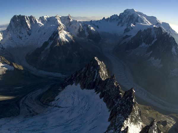
Mont Blanc. Glaciers coat the valley north of Mont Blanc near Chamonix, France. At a length of 8 miles (12 kilometers), Mer de Glace, or Sea of Ice, is one of the largest glaciers in the Alps.
Estimates indicate the Alps have lost about half their glacial ice in the past century. And if climate change trends continue, they could lose 50 to 80 percent of their remaining glaciers by 2100.
Estimates indicate the Alps have lost about half their glacial ice in the past century. And if climate change trends continue, they could lose 50 to 80 percent of their remaining glaciers by 2100.
Columbia Glacier. Massive Columbia Glacier, photographed here in June 2006, wends its way through western Alaska's Chugach Mountains. The bald streak at the bottom of the mountains, called the trimline, shows this glacier has lost 1,300 feet (400 meters) of thickness since its maximum in 1984. It has also retreated 10.5 miles (17 kilometers) since that time.
After the last camera is collected in the summer of 2009, Extreme Ice Survey founder James Balog will begin to stitch the hundreds of thousands of images together into a multimedia educational package, a documentary, and a traveling exhibition—all designed to draw attention to global warming.
After the last camera is collected in the summer of 2009, Extreme Ice Survey founder James Balog will begin to stitch the hundreds of thousands of images together into a multimedia educational package, a documentary, and a traveling exhibition—all designed to draw attention to global warming.

--
Source: http://www.cornermystery.com/2011/02/photos-survey-of-extreme-ice.html
~
Manage subscription | Powered by rssforward.com


0 komentar:
Posting Komentar